 vesseltracker.com
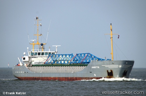
 Sandettie
Current Status
Where is the vessel?
Sandettie is currently in Near Llanwrda, based on AIS data received less than 1h ago.
Latest AIS update:
Current position: 51.92280° N, 3.71458° E (Near Llanwrda)
Average speed (last 7 days): Loading…
Average speed (last 30 days): Loading…
Vessel profile: Sandettie is a General Cargo Ship with dimensions 89m x 89m.
This page combines live AIS, route history, probable destination signals, nearby traffic, and port activity for practical vessel monitoring.
The current position of vessel Sandettie is 51.92280 lat / 3.71458 lng. Updated: 2026-04-17 16:00:55 UTCNearest reference points:
- 12 nm NE of Hunsdon
- Near DEN OSSE
- Near Haarlemmermeer
Currently sailing under the flag of Netherlands ![]()
Sandettie built in 2004 year
Deadweight:
2934 tDetails:
Live Vessel Sandettie Analytics (details, animations, etc.)
Recent AIS points (UTC):
2026-04-17 10:12:41 UTC · 51.89973, 3.27501 · SOG 8.6 kn · COG 71°2026-04-17 12:23:51 UTC · 51.92336, 3.70994 · SOG 1.7 kn · COG 173°
2026-04-17 14:20:09 UTC · 51.92282, 3.71461 · SOG 0 kn · COG 223°
2026-04-17 16:00:55 UTC · 51.92280, 3.71458 · SOG 0 kn · COG 224°