 vesseltracker.com
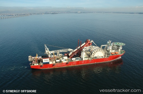
 Deep Blue
Current Status
Where is the vessel?
Deep Blue is currently in 26 nm S of MAZARA DEL VALLO, based on AIS data received about 1h ago.
Latest AIS update:
Current position: 37.21395° N, 12.48024° E (26 nm S of MAZARA DEL VALLO)
Average speed (last 7 days): Loading…
Average speed (last 30 days): Loading…
Vessel profile: Deep Blue is a Pipe Layer with dimensions 206m x 32m.
This page combines live AIS, route history, probable destination signals, nearby traffic, and port activity for practical vessel monitoring.
The current position of vessel Deep Blue is 37.21395 lat / 12.48024 lng. Updated: 2026-04-26 20:18:44 UTCNearest reference points:
- Near MARSALA
- Near Trapani
- Near Balestrate
Currently sailing under the flag of Bahamas ![]()
Deep Blue built in 2001 year
Deadweight:
25449 tDetails:
Live Vessel Deep Blue Analytics (details, animations, etc.)
Recent AIS points (UTC):
2026-04-26 16:38:44 UTC · 37.53987, 11.95868 · SOG 8.1 kn · COG 123°2026-04-26 18:26:22 UTC · 37.37338, 12.20057 · SOG 8.5 kn · COG 124°
2026-04-26 19:48:35 UTC · 37.26165, 12.40968 · SOG 8.5 kn · COG 113°
2026-04-26 20:18:44 UTC · 37.21395, 12.48024 · SOG 8.8 kn · COG 131°