 vesseltracker.com
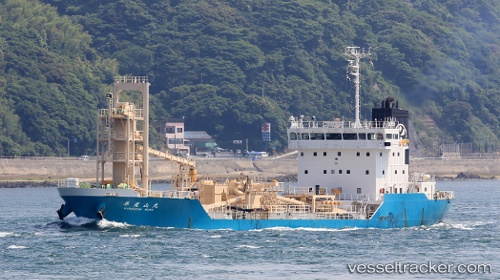
Hiraozanmaru
Current StatusWhere is the vessel?
Hiraozanmaru is currently in Near KANDA, based on AIS data received less than 1h ago.
Latest AIS update:
Current position: 33.80335° N, 131.03004° E (Near KANDA)
Average speed (last 7 days): Loading…
Average speed (last 30 days): Loading…
Vessel profile: Hiraozanmaru is a Cement Carrier with dimensions 20m x 93m.
This page combines live AIS, route history, probable destination signals, nearby traffic, and port activity for practical vessel monitoring.
The current position of vessel Hiraozanmaru is 33.80335 lat / 131.03004 lng. Updated: 2026-05-15 00:16:15 UTCNearest reference points:
- Near KANDA
- Near Kanmon
- Near Shimonoseki
Details:
Live Vessel Hiraozanmaru Analytics (details, animations, etc.)
Recent AIS points (UTC):
2026-05-14 19:54:41 UTC · 33.77167, 130.99834 · SOG 0 kn · COG -1°2026-05-14 21:24:39 UTC · 33.77167, 130.99834 · SOG 0 kn · COG -1°
2026-05-14 22:18:40 UTC · 33.77167, 130.99834 · SOG 0 kn · COG -1°
2026-05-15 00:16:15 UTC · 33.80335, 131.03004 · SOG 9.2 kn · COG 92°