 vesseltracker.com
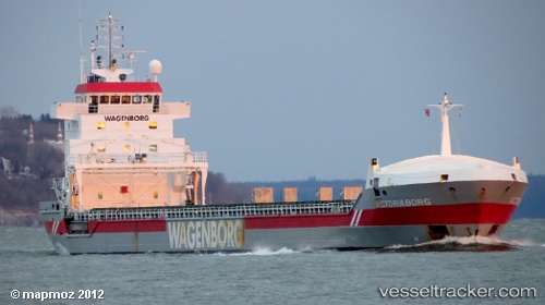
 Victoriaborg
Current Status
Where is the vessel?
Victoriaborg is currently in 35 nm NE of Lachassagne, based on AIS data received less than 1h ago.
Latest AIS update:
Current position: 57.45824° N, 5.15552° E (35 nm NE of Lachassagne)
Average speed (last 7 days): Loading…
Average speed (last 30 days): Loading…
Vessel profile: Victoriaborg is a General Cargo Ship with dimensions 133m x 17m.
This page combines live AIS, route history, probable destination signals, nearby traffic, and port activity for practical vessel monitoring.
The current position of vessel Victoriaborg is 57.45824 lat / 5.15552 lng. Updated: 2026-05-15 22:11:53 UTCNearest reference points:
- Near Egersund
- Near Åna-Sira
- Near Lura
Currently sailing under the flag of Netherlands ![]()
Victoriaborg built in 2001 year
Deadweight:
9850 tDetails:
Live Vessel Victoriaborg Analytics (details, animations, etc.)
Recent AIS points (UTC):
2026-05-15 19:08:56 UTC · 57.98881, 4.77907 · SOG 10.9 kn · COG 158°2026-05-15 19:54:46 UTC · 57.85717, 4.86453 · SOG 11 kn · COG 160°
2026-05-15 21:45:45 UTC · 57.53641, 5.10243 · SOG 11.4 kn · COG 159°
2026-05-15 22:11:53 UTC · 57.45824, 5.15552 · SOG 11.2 kn · COG 158°