 vesseltracker.com
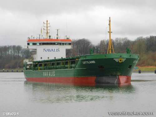
 Lettland
Current Status
Where is the vessel?
Lettland is currently in 13 nm S of Kallviken, based on AIS data received less than 1h ago.
Latest AIS update:
Current position: 60.16419° N, 26.32415° E (13 nm S of Kallviken)
Average speed (last 7 days): Loading…
Average speed (last 30 days): Loading…
Vessel profile: Lettland is a Multi Purpose Carrier with dimensions 100m x 17m.
This page combines live AIS, route history, probable destination signals, nearby traffic, and port activity for practical vessel monitoring.
The current position of vessel Lettland is 60.16419 lat / 26.32415 lng. Updated: 2026-05-15 13:42:14 UTCNearest reference points:
- Near Vessölandet
- 13 nm N of Viinistu Sadam
- Near Lakulahti
Currently sailing under the flag of Portugal ![]()
Lettland built in 2001 year
Deadweight:
5021 tDetails:
Live Vessel Lettland Analytics (details, animations, etc.)
Recent AIS points (UTC):
2026-05-15 09:40:09 UTC · 60.43667, 26.91500 · SOG 0 kn · COG -1°2026-05-15 10:29:32 UTC · 60.43789, 26.91605 · SOG 0 kn · COG 64°
2026-05-15 11:42:44 UTC · 60.40370, 26.87080 · SOG 11.2 kn · COG 243°
2026-05-15 13:42:14 UTC · 60.16419, 26.32415 · SOG 11.1 kn · COG 224°