 vesseltracker.com
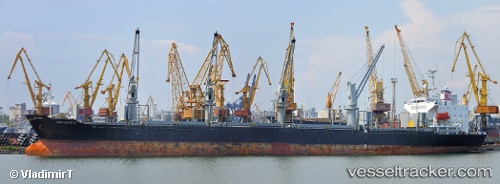
 LADY ILEEN
Current Status
Where is the vessel?
LADY ILEEN is currently in 36 nm N of Offshore Fujairah, based on AIS data received about 1h ago.
Latest AIS update:
Current position: 25.81297° N, 56.89973° E (36 nm N of Offshore Fujairah)
Average speed (last 7 days): Loading…
Average speed (last 30 days): Loading…
Vessel profile: LADY ILEEN is a Bulk Carrier with dimensions m x m.
This page combines live AIS, route history, probable destination signals, nearby traffic, and port activity for practical vessel monitoring.
The current position of vessel LADY ILEEN is 25.81297 lat / 56.89973 lng. Updated: 2026-04-24 14:06:52 UTCNearest reference points:
- 34 nm NE of Offshore Fujairah
- 30 nm NE of Offshore Fujairah
- 29 nm NE of Offshore Fujairah
Currently sailing under the flag of Palau ![]()
Details:
Live Vessel LADY ILEEN Analytics (details, animations, etc.)
Recent AIS points (UTC):
2026-04-24 10:20:10 UTC · 25.81110, 56.89779 · SOG 0.2 kn · COG 74°2026-04-24 12:03:01 UTC · 25.81299, 56.89971 · SOG 0.1 kn · COG 187°
2026-04-24 12:51:55 UTC · 25.81306, 56.89964 · SOG 0.8 kn · COG 194°
2026-04-24 14:06:52 UTC · 25.81297, 56.89973 · SOG 0.7 kn · COG 201°