 vesseltracker.com
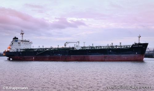
 Mt.emmanuel
Current Status
Where is the vessel?
Mt.emmanuel is currently in 35 nm NE of Gunungsari, based on AIS data received about 2d ago.
Latest AIS update:
Current position: 6.09735° S, 108.62507° E (35 nm NE of Gunungsari)
Average speed (last 7 days): Loading…
Average speed (last 30 days): Loading…
Vessel profile: Mt.emmanuel is a Chemical Oil Products Tanker with dimensions 182m x 28m.
This page combines live AIS, route history, probable destination signals, nearby traffic, and port activity for practical vessel monitoring.
The current position of vessel Mt.emmanuel is -6.09735 lat / 108.62507 lng. Updated: 2026-05-14 06:44:46 UTCNearest reference points:
- 25 nm N of Gunungsari
- 26 nm N of Pemalang
- 31 nm NE of Rengasdengklok
Currently sailing under the flag of Indonesia ![]()
Mt.emmanuel built in 2002 year
Deadweight:
37113 tDetails:
Live Vessel Mt.emmanuel Analytics (details, animations, etc.)
Recent AIS points (UTC):
2026-05-14 06:44:46 UTC · -6.09735, 108.62507 · SOG 11.7 kn · COG -1°2026-05-14 06:44:46 UTC · -6.09735, 108.62507 · SOG 11.7 kn · COG -1°
2026-05-14 06:44:46 UTC · -6.09735, 108.62507 · SOG 11.7 kn · COG -1°
2026-05-14 06:44:46 UTC · -6.09735, 108.62507 · SOG 11.7 kn · COG -1°