 vesseltracker.com
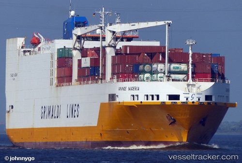
Grande Nigeria
Current StatusWhere is the vessel?
Grande Nigeria is currently in Near Casablanca, based on AIS data received less than 1h ago.
Latest AIS update:
Current position: 33.77130° N, 7.63500° W (Near Casablanca)
Average speed (last 7 days): Loading…
Average speed (last 30 days): Loading…
Vessel profile: Grande Nigeria is a Vehicles Carrier with dimensions 32m x 214m.
This page combines live AIS, route history, probable destination signals, nearby traffic, and port activity for practical vessel monitoring.
The current position of vessel Grande Nigeria is 33.77130 lat / -7.63500 lng. Updated: 2026-05-15 21:26:24 UTCNearest reference points:
- Near Mohammedia
- 54 nm N of El Jadida
- Near Jorf Lasfar
Details:
Live Vessel Grande Nigeria Analytics (details, animations, etc.)
Recent AIS points (UTC):
2026-05-15 17:35:04 UTC · 33.93634, -7.49912 · SOG 4.3 kn · COG 44°2026-05-15 19:26:55 UTC · 33.81361, -7.60363 · SOG 1.3 kn · COG 277°
2026-05-15 20:00:04 UTC · 33.80397, -7.61333 · SOG 1.4 kn · COG 283°
2026-05-15 21:26:24 UTC · 33.77130, -7.63500 · SOG 1.8 kn · COG 280°