 vesseltracker.com
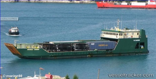
 EMERALD EXPRESS
Current Status
Where is the vessel?
EMERALD EXPRESS is currently in Near Port Laudania, based on AIS data received less than 1h ago.
Latest AIS update:
Current position: 26.06572° N, 80.11546° W (Near Port Laudania)
Average speed (last 7 days): Loading…
Average speed (last 30 days): Loading…
Vessel profile: EMERALD EXPRESS is a Landing Craft with dimensions m x m.
This page combines live AIS, route history, probable destination signals, nearby traffic, and port activity for practical vessel monitoring.
The current position of vessel EMERALD EXPRESS is 26.06572 lat / -80.11546 lng. Updated: 2026-05-15 07:18:03 UTCNearest reference points:
- Near Dania Beach
- Near Port Everglades
- Near Fort Lauderdale
Currently sailing under the flag of Antigua and Barbuda ![]()
Details:
Live Vessel EMERALD EXPRESS Analytics (details, animations, etc.)
Recent AIS points (UTC):
2026-05-15 03:56:50 UTC · 26.04321, -79.95607 · SOG 6.8 kn · COG 261°2026-05-15 04:16:50 UTC · 26.05378, -79.99635 · SOG 6.6 kn · COG 270°
2026-05-15 05:44:28 UTC · 26.08429, -80.11372 · SOG 5.1 kn · COG 182°
2026-05-15 07:18:03 UTC · 26.06572, -80.11546 · SOG 0 kn · COG 205°