 vesseltracker.com
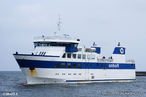
 Anholt
Current Status
Where is the vessel?
Anholt is currently in 26 nm NE of Grena, based on AIS data received less than 1h ago.
Latest AIS update:
Current position: 56.71580° N, 11.51120° E (26 nm NE of Grena)
Average speed (last 7 days): Loading…
Average speed (last 30 days): Loading…
Vessel profile: Anholt is a Passenger Ro Ro Cargo Ship with dimensions 48m x 12m.
This page combines live AIS, route history, probable destination signals, nearby traffic, and port activity for practical vessel monitoring.
The current position of vessel Anholt is 56.7158 lat / 11.5112 lng. Updated: 2026-04-27 23:39:58 UTCNearest reference points:
- Near Grena
- 11 nm NW of Tisvilde
- 19 nm E of Sæby
Currently sailing under the flag of Denmark ![]()
Anholt built in 2003 year
Deadweight:
172 tDetails:
Live Vessel Anholt Analytics (details, animations, etc.)
Recent AIS points (UTC):
2026-04-27 20:13:20 UTC · 56.71590, 11.51140 · SOG 0 kn · COG 106°2026-04-27 22:02:50 UTC · 56.71580, 11.51140 · SOG 0 kn · COG 106°
2026-04-27 22:48:09 UTC · 56.71580, 11.51140 · SOG 0 kn · COG 107°
2026-04-27 23:39:58 UTC · 56.71580, 11.51120 · SOG 0 kn · COG 106°