 vesseltracker.com
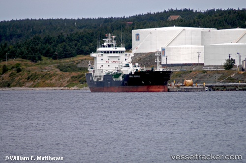
 ASPHALT TERANGA
Current Status
Where is the vessel?
ASPHALT TERANGA is currently in 84 nm NW of Utiel, based on AIS data received about 1h ago.
Latest AIS update:
Current position: 40.19607° N, 12.78717° W (84 nm NW of Utiel)
Average speed (last 7 days): Loading…
Average speed (last 30 days): Loading…
Vessel profile: ASPHALT TERANGA is a Asphalt/Bitumen Tanker with dimensions 108m x 20m.
This page combines live AIS, route history, probable destination signals, nearby traffic, and port activity for practical vessel monitoring.
The current position of vessel ASPHALT TERANGA is 40.19607 lat / -12.78717 lng. Updated: 2026-05-16 15:08:18 UTCNearest reference points:
- 43 nm NW of Utiel
- 25 nm S of Bear River City
- 20 nm SE of Bear River City
Currently sailing under the flag of Panama ![]()
ASPHALT TERANGA built in 2005 year
Deadweight:
9230 tDetails:
Live Vessel ASPHALT TERANGA Analytics (details, animations, etc.)
Recent AIS points (UTC):
2026-05-16 10:04:29 UTC · 39.45997, -12.99099 · SOG 8.5 kn · COG 18°2026-05-16 12:57:18 UTC · 39.87370, -12.85884 · SOG 8.3 kn · COG 10°
2026-05-16 12:57:18 UTC · 39.87370, -12.85884 · SOG 8.3 kn · COG 10°
2026-05-16 15:08:18 UTC · 40.19607, -12.78717 · SOG 8.8 kn · COG 6°