 vesseltracker.com
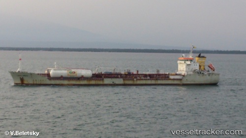
 GALATIA KA
Current Status
Where is the vessel?
GALATIA KA is currently in Near Inousses, based on AIS data received about 1h ago.
Latest AIS update:
Current position: 38.63656° N, 26.26870° E (Near Inousses)
Average speed (last 7 days): Loading…
Average speed (last 30 days): Loading…
Vessel profile: GALATIA KA is a Oil/Chemical Tanker with dimensions m x m.
This page combines live AIS, route history, probable destination signals, nearby traffic, and port activity for practical vessel monitoring.
The current position of vessel GALATIA KA is 38.63656 lat / 26.26870 lng. Updated: 2026-05-14 10:07:41 UTCNearest reference points:
- Near CESME
- Near Nemrut Bay
- Near NEMRUT
Currently sailing under the flag of Turkey ![]()
Details:
Live Vessel GALATIA KA Analytics (details, animations, etc.)
Recent AIS points (UTC):
2026-05-14 07:23:12 UTC · 38.18552, 26.21208 · SOG 10.8 kn · COG 338°2026-05-14 07:26:12 UTC · 38.19402, 26.20821 · SOG 10.8 kn · COG 340°
2026-05-14 09:35:52 UTC · 38.55689, 26.30193 · SOG 10.5 kn · COG 329°
2026-05-14 10:07:41 UTC · 38.63656, 26.26870 · SOG 10.8 kn · COG 29°