 vesseltracker.com
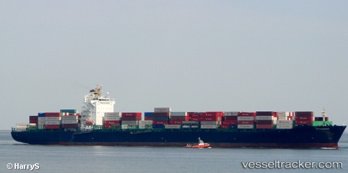
 STAMATIS B
Current Status
Where is the vessel?
STAMATIS B is currently in 42 nm S of Lome, based on AIS data received less than 1h ago.
Latest AIS update:
Current position: 5.41778° N, 1.25102° E (42 nm S of Lome)
Average speed (last 7 days): Loading…
Average speed (last 30 days): Loading…
Vessel profile: STAMATIS B is a Container Ship with dimensions 32m x 261m.
This page combines live AIS, route history, probable destination signals, nearby traffic, and port activity for practical vessel monitoring.
The current position of vessel STAMATIS B is 5.41778 lat / 1.25102 lng. Updated: 2026-05-14 21:58:28 UTCNearest reference points:
- Near Ablogamé
- Near Cotonou
- Near Apapa
Currently sailing under the flag of Liberia ![]()
STAMATIS B built in 2004 year
Deadweight:
55497 tDetails:
Live Vessel STAMATIS B Analytics (details, animations, etc.)
Recent AIS points (UTC):
2026-05-14 17:22:05 UTC · 5.82487, 2.53375 · SOG 17.4 kn · COG 250°2026-05-14 19:41:24 UTC · 5.62297, 1.88980 · SOG 17.6 kn · COG 249°
2026-05-14 19:59:40 UTC · 5.59337, 1.80455 · SOG 17.6 kn · COG 250°
2026-05-14 21:58:28 UTC · 5.41778, 1.25102 · SOG 17 kn · COG 253°