 vesseltracker.com
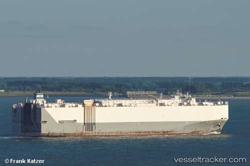
 Alliance St. Louis
Current Status
Where is the vessel?
Alliance St. Louis is currently in Near Yanbu Industrial City, based on AIS data received less than 1h ago.
Latest AIS update:
Current position: 23.95833° N, 38.20833° E (Near Yanbu Industrial City)
Average speed (last 7 days): Loading…
Average speed (last 30 days): Loading…
Vessel profile: Alliance St. Louis is a Vehicles Carrier with dimensions 200m x 32m.
This page combines live AIS, route history, probable destination signals, nearby traffic, and port activity for practical vessel monitoring.
The current position of vessel Alliance St. Louis is 23.95833 lat / 38.20833 lng. Updated: 2026-04-28 21:39:21 UTCNearest reference points:
- 30 nm SW of Yanbu
- 42 nm NW of Fiji
- 35 nm S of Umm Lajj
Currently sailing under the flag of USA ![]()
Alliance St. Louis built in 2005 year
Deadweight:
15880 tDetails:
Live Vessel Alliance St. Louis Analytics (details, animations, etc.)
Recent AIS points (UTC):
2026-04-28 16:15:16 UTC · 23.95870, 38.20927 · SOG 0 kn · COG 313°2026-04-28 18:03:16 UTC · 23.95868, 38.20925 · SOG 0 kn · COG 313°
2026-04-28 19:21:16 UTC · 23.95868, 38.20926 · SOG 0 kn · COG 313°
2026-04-28 21:39:21 UTC · 23.95833, 38.20833 · SOG 0 kn · COG -1°