 vesseltracker.com
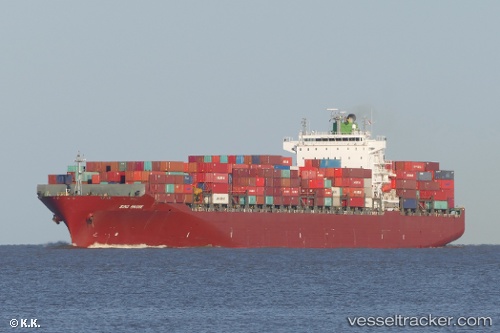
 Sino Bridge
Current Status
Where is the vessel?
Sino Bridge is currently in 11 nm S of Freeport, based on AIS data received less than 1h ago.
Latest AIS update:
Current position: 26.34227° N, 78.80562° W (11 nm S of Freeport)
Average speed (last 7 days): Loading…
Average speed (last 30 days): Loading…
Vessel profile: Sino Bridge is a Container Ship with dimensions 294m x 32m.
This page combines live AIS, route history, probable destination signals, nearby traffic, and port activity for practical vessel monitoring.
The current position of vessel Sino Bridge is 26.34227 lat / -78.80562 lng. Updated: 2026-05-15 08:08:37 UTCNearest reference points:
- 44 nm S of Freeport
- 44 nm E of Surfside
- Near Fort Lauderdale
Currently sailing under the flag of Panama ![]()
Sino Bridge built in 2004 year
Deadweight:
65038 tDetails:
Live Vessel Sino Bridge Analytics (details, animations, etc.)
Recent AIS points (UTC):
2026-05-15 04:16:47 UTC · 26.36142, -78.72772 · SOG 1.2 kn · COG 125°2026-05-15 05:44:27 UTC · 26.34898, -78.75858 · SOG 1.2 kn · COG 109°
2026-05-15 07:20:28 UTC · 26.34252, -78.78910 · SOG 1 kn · COG 95°
2026-05-15 08:08:37 UTC · 26.34227, -78.80562 · SOG 1.3 kn · COG 55°