 vesseltracker.com
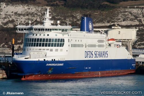
 Dunkerque Seaways
Current Status
Where is the vessel?
Dunkerque Seaways is currently in Near Calais, based on AIS data received less than 1h ago.
Latest AIS update:
Current position: 51.03581° N, 1.82869° E (Near Calais)
Average speed (last 7 days): Loading…
Average speed (last 30 days): Loading…
Vessel profile: Dunkerque Seaways is a Passenger Ro Ro Cargo Ship with dimensions 186m x 28m.
This page combines live AIS, route history, probable destination signals, nearby traffic, and port activity for practical vessel monitoring.
The current position of vessel Dunkerque Seaways is 51.03581 lat / 1.82869 lng. Updated: 2026-05-15 22:12:06 UTCNearest reference points:
- Near Calais
- 14 nm SE of RAMSGATE
- Near Sangatte
Currently sailing under the flag of United Kingdom ![]()
Dunkerque Seaways built in 2005 year
Deadweight:
6160 tDetails:
Live Vessel Dunkerque Seaways Analytics (details, animations, etc.)
Recent AIS points (UTC):
2026-05-15 19:08:58 UTC · 51.05231, 1.62130 · SOG 13.5 kn · COG 311°2026-05-15 19:54:56 UTC · 51.12192, 1.37484 · SOG 13.7 kn · COG 274°
2026-05-15 21:47:35 UTC · 51.06319, 1.65071 · SOG 16.1 kn · COG 126°
2026-05-15 22:12:06 UTC · 51.03581, 1.82869 · SOG 17.9 kn · COG 102°