 vesseltracker.com
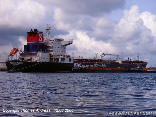
 CHEMTRANS TAURUS
Current Status
Where is the vessel?
CHEMTRANS TAURUS is currently in Near Gregory' Lake Apt (Nuwara Eliya), based on AIS data received about 6d ago.
Latest AIS update:
Current position: 8.50195° N, 81.23186° E (Near Gregory' Lake Apt (Nuwara Eliya))
Average speed (last 7 days): Loading…
Average speed (last 30 days): Loading…
Vessel profile: CHEMTRANS TAURUS is a Crude Oil Tanker with dimensions m x m.
This page combines live AIS, route history, probable destination signals, nearby traffic, and port activity for practical vessel monitoring.
The current position of vessel CHEMTRANS TAURUS is 8.50195 lat / 81.23186 lng. Updated: 2026-05-07 04:56:12 UTCNearest reference points:
- 67 nm E of Oluvil
- 42 nm E of Konwelana
- 40 nm E of Konwelana
Currently sailing under the flag of Marshall Islands ![]()
Details:
Live Vessel CHEMTRANS TAURUS Analytics (details, animations, etc.)
Recent AIS points (UTC):
2026-05-07 04:56:12 UTC · 8.50195, 81.23186 · SOG 0.1 kn · COG 350°2026-05-07 04:56:12 UTC · 8.50195, 81.23186 · SOG 0.1 kn · COG 350°
2026-05-07 04:56:12 UTC · 8.50195, 81.23186 · SOG 0.1 kn · COG 350°
2026-05-07 04:56:12 UTC · 8.50195, 81.23186 · SOG 0.1 kn · COG 350°