 vesseltracker.com
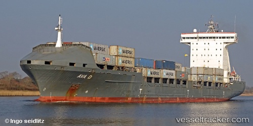
 AVA D
AVA D
Current Status
Where is the vessel?
AVA D is currently in Near Kotka, based on AIS data received less than 1h ago.
Latest AIS update:
Current position: 60.42026° N, 26.91164° E (Near Kotka)
Average speed (last 7 days): Loading…
Average speed (last 30 days): Loading…
Vessel profile: AVA D is a Container Ship with dimensions 168m x 26m.
This page combines live AIS, route history, probable destination signals, nearby traffic, and port activity for practical vessel monitoring.
The current position of vessel AVA D is 60.42026 lat / 26.91164 lng. Updated: 2026-05-14 05:56:35 UTCNearest reference points:
- Near Lakulahti
- 27 nm S of Klamila
- Near Vessölandet
Currently sailing under the flag of Portugal (MAR) ![]()
AVA D built in 2007 year
Deadweight:
20646 tDetails:
Live Vessel AVA D Analytics (details, animations, etc.)
Recent AIS points (UTC):
2026-05-14 02:02:36 UTC · 60.42030, 26.91161 · SOG 0 kn · COG 319°2026-05-14 03:50:35 UTC · 60.42031, 26.91164 · SOG 0 kn · COG 319°
2026-05-14 05:02:35 UTC · 60.42034, 26.91161 · SOG 0 kn · COG 319°
2026-05-14 05:56:35 UTC · 60.42026, 26.91164 · SOG 0 kn · COG 318°