 vesseltracker.com
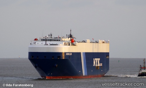
Dorado Leader
Current StatusWhere is the vessel?
Dorado Leader is currently in 270 nm N of Islas Juan Fernandez, based on AIS data received about 1h ago.
Latest AIS update:
Current position: 29.20884° S, 77.84032° W (270 nm N of Islas Juan Fernandez)
Average speed (last 7 days): Loading…
Average speed (last 30 days): Loading…
Vessel profile: Dorado Leader is a Vehicles Carrier with dimensions 32m x 200m.
This page combines live AIS, route history, probable destination signals, nearby traffic, and port activity for practical vessel monitoring.
The current position of vessel Dorado Leader is -29.20884 lat / -77.84032 lng. Updated: 2026-05-14 16:47:37 UTCNearest reference points:
- Open sea, approx. 400 nm off the nearest listed port
- Open sea, approx. 439 nm off the nearest listed port
- Open sea, approx. 538 nm off the nearest listed port
Details:
Live Vessel Dorado Leader Analytics (details, animations, etc.)
Recent AIS points (UTC):
2026-05-14 13:37:22 UTC · -29.79280, -77.02483 · SOG 17.2 kn · COG 312°2026-05-14 14:13:49 UTC · -29.68160, -77.17728 · SOG 17.1 kn · COG 310°
2026-05-14 16:19:48 UTC · -29.29859, -77.72131 · SOG 17.7 kn · COG 308°
2026-05-14 16:47:37 UTC · -29.20884, -77.84032 · SOG 17.8 kn · COG 312°