 vesseltracker.com
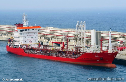
 Tingis
Current Status
Where is the vessel?
Tingis is currently in Near Casablanca, based on AIS data received less than 1h ago.
Latest AIS update:
Current position: 33.60227° N, 7.61625° W (Near Casablanca)
Average speed (last 7 days): Loading…
Average speed (last 30 days): Loading…
Vessel profile: Tingis is a Chemical Oil Products Tanker with dimensions 119m x 119m.
This page combines live AIS, route history, probable destination signals, nearby traffic, and port activity for practical vessel monitoring.
The current position of vessel Tingis is 33.60227 lat / -7.61625 lng. Updated: 2026-05-14 18:07:58 UTCNearest reference points:
- Near Mohammedia
- Near Jorf Lasfar
- 54 nm N of El Jadida
Currently sailing under the flag of Morocco ![]()
Tingis built in 2005 year
Deadweight:
6937 tDetails:
Live Vessel Tingis Analytics (details, animations, etc.)
Recent AIS points (UTC):
2026-05-14 13:58:59 UTC · 33.60227, -7.61627 · SOG 0 kn · COG 183°2026-05-14 15:37:46 UTC · 33.60225, -7.61625 · SOG 0 kn · COG 183°
2026-05-14 16:34:01 UTC · 33.60227, -7.61623 · SOG 0 kn · COG 183°
2026-05-14 18:07:58 UTC · 33.60227, -7.61625 · SOG 0 kn · COG 183°