 vesseltracker.com
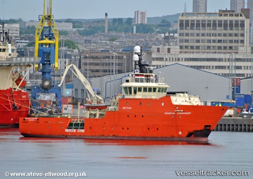
 Grampian Commander
Current Status
Where is the vessel?
Grampian Commander is currently in 25 nm SE of Athena FPSO, based on AIS data received about 1d ago.
Latest AIS update:
Current position: 58.42939° N, 0.27847° W (25 nm SE of Athena FPSO)
Average speed (last 7 days): Loading…
Average speed (last 30 days): Loading…
Vessel profile: Grampian Commander is a Standby Safety Vessel with dimensions 48m x 12m.
This page combines live AIS, route history, probable destination signals, nearby traffic, and port activity for practical vessel monitoring.
The current position of vessel Grampian Commander is 58.42939 lat / -0.27847 lng. Updated: 2026-05-16 15:21:39 UTCNearest reference points:
- Near Alba Oil Field
- Near Peterhead
- Near PETERHEAD
Currently sailing under the flag of United Kingdom ![]()
Grampian Commander built in 2005 year
Deadweight:
488 tDetails:
Live Vessel Grampian Commander Analytics (details, animations, etc.)
Recent AIS points (UTC):
2026-05-16 15:21:39 UTC · 58.42939, -0.27847 · SOG 1.4 kn · COG 302°2026-05-16 15:21:39 UTC · 58.42939, -0.27847 · SOG 1.4 kn · COG 302°
2026-05-16 15:21:39 UTC · 58.42939, -0.27847 · SOG 1.4 kn · COG 302°
2026-05-16 15:21:39 UTC · 58.42939, -0.27847 · SOG 1.4 kn · COG 302°