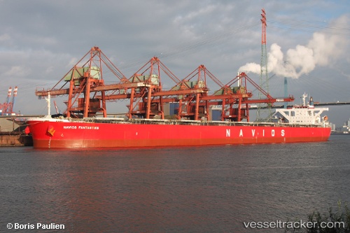
.
Vessel photo of Navios Fantastiks (IMO 9325013) vesseltracker.com

Navios Fantastiks

Vessel type: Bulk Carrier | IMO: 9325013 | MMSI: MMSI: 356704000
Call sign: 3EAJ2 | Dimensions: 45 m x 288 m
Current Status

Where is the vessel?

Navios Fantastiks is currently in 40 nm SW of Stilbaai, based on AIS data received less than 1h ago.

Latest AIS update:

Current position: 34.93673° S, 20.98650° E (40 nm SW of Stilbaai)

Average speed (last 7 days): Loading…

Average speed (last 30 days): Loading…

Vessel profile: Navios Fantastiks is a Bulk Carrier with dimensions 45m x 288m.

This page combines live AIS, route history, probable destination signals, nearby traffic, and port activity for practical vessel monitoring.

The current position of vessel Navios Fantastiks is -34.93673 lat / 20.98650 lng. Updated: 2026-05-15 18:05:55 UTC
Nearest reference points:
  • 37 nm S of Mosselbaai
  • 16 nm S of Mosselbaai
  • Near Mosselbaai
Details:

Live Vessel Navios Fantastiks Analytics (details, animations, etc.)


Recent AIS points (UTC):
2026-05-15 14:03:02 UTC · -34.85250, 21.67853 · SOG 8.6 kn · COG 260°
2026-05-15 16:08:52 UTC · -34.89633, 21.32008 · SOG 8.5 kn · COG 258°
2026-05-15 17:05:29 UTC · -34.91564, 21.15759 · SOG 8.6 kn · COG 260°
2026-05-15 18:05:55 UTC · -34.93673, 20.98650 · SOG 8.5 kn · COG 259°

Track of the vessel in the last 60 days


UTC: --
Start: -- Track timeline (UTC) End: --
Encountered: --


Link to the map:


Find another ship

Navios_Fantastiks (356704000) last ports (portcalls and passsages)

Port Elizabeth | 2025-08-27 13:51:12
Port Louis | 2025-07-15 04:22:23
BUKOM ISLAND | 2025-07-01 18:45:16
BATU AMPAR | 2025-07-01 17:26:03
TANAH MERAH | 2025-06-30 18:42:50
PENGERANG | 2025-06-30 17:31:27
HUANGHUA | 2025-06-16 14:23:39
BAKAUHENI | 2025-06-02 11:13:22
BUKOM ISLAND | 2025-03-02 05:37:15
PULAU SAMBU | 2025-03-02 05:14:57
TANAH MERAH | 2025-02-28 05:28:48
PENGERANG | 2025-02-28 04:36:54
DONGJIAKOU | 2025-02-17 00:24:59
Fangcheng | 2025-02-05 16:34:41
SURALAYA | 2025-01-26 05:18:59
CIWANDAN | 2025-01-24 00:38:30
Selat Sunda | 2025-01-23 23:27:11
Port Louis | 2025-01-11 10:55:02
Takoradi | 2024-12-19 03:21:10
Takoradi | 2024-12-15 02:19:00
Takoradi | 2024-12-11 00:57:42
PULAU SAMBU | 2024-11-09 18:00:45
BATU AMPAR | 2024-11-09 16:55:08
PENGERANG | 2024-11-08 21:57:01
Port Louis | 2024-09-28 21:10:52
Ponta da Madeira | 2024-08-25 09:28:47
Wusong | 2024-07-06 05:18:27
Nantong | 2024-07-03 09:04:11
Taicang | 2024-07-03 05:24:37
Jingjiang | 2024-07-02 21:12:23
Saldanha Bay | 2024-05-24 21:43:37
Saldanha Bay | 2024-05-19 15:18:40
Singapore | 2024-04-19 02:14:37
Jingjiang | 2024-03-02 01:34:41
Wusong | 2024-03-01 20:54:24
Taicang | 2024-03-01 19:13:53
Nantong | 2024-03-01 05:49:00
Taixing | 2024-02-26 14:24:20
Zhangjiagang | 2024-02-26 11:24:03
Wusong | 2024-02-26 05:07:59
Jingjiang | 2024-02-26 00:02:19
Singapore | 2024-01-27 11:44:11
Port Louis | 2024-01-11 11:50:23
Sambu | 2023-10-25 06:17:10
Singapore | 2023-10-08 21:10:56
Qingdao | 2023-03-21 20:31:56
Singapore | 2023-03-10 23:50:13
Port Elizabeth | 2023-02-18 08:42:52
Port Elizabeth | 2023-01-13 08:34:27
Ras Gharib | 2022-10-02 01:59:42
Ceuta | 2022-09-22 07:53:29
Bishop Rock | 2022-08-14 19:56:39
Santa Marta | 2022-06-27 16:25:51
Cuxhaven | 2022-04-07 12:05:20
Stadersand | 2022-04-07 09:00:37
Mobile | 2022-03-08 09:37:12
Strait Of Gibraltar | 2022-02-05 15:35:04
Algeciras | 2022-02-04 21:05:08
Port Said | 2022-01-26 17:06:38
Bur Ibrahim | 2021-12-18 16:45:13
Port Said | 2021-12-18 07:35:13
Strait Of Gibraltar | 2021-12-08 23:40:09