 vesseltracker.com
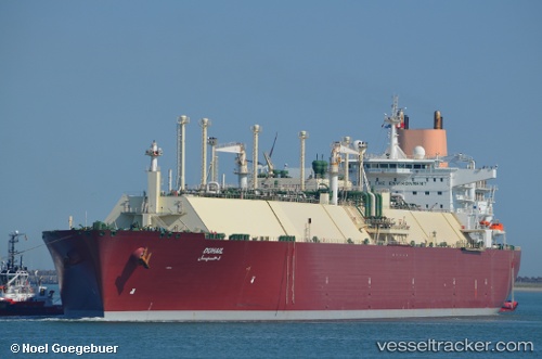
 Duhail
Current Status
Where is the vessel?
Duhail is currently in 119 nm NW of Pointe aux Canonniers, based on AIS data received less than 1h ago.
Latest AIS update:
Current position: 18.56423° S, 56.09517° E (119 nm NW of Pointe aux Canonniers)
Average speed (last 7 days): Loading…
Average speed (last 30 days): Loading…
Vessel profile: Duhail is a Lng Tanker with dimensions 315m x 50m.
This page combines live AIS, route history, probable destination signals, nearby traffic, and port activity for practical vessel monitoring.
The current position of vessel Duhail is -18.56423 lat / 56.09517 lng. Updated: 2026-04-28 07:18:52 UTCNearest reference points:
- 164 nm NW of Pointe aux Canonniers
- Near Port Louis
Currently sailing under the flag of Bahamas ![]()
Duhail built in 2008 year
Deadweight:
121639 tDetails:
Live Vessel Duhail Analytics (details, animations, etc.)
Recent AIS points (UTC):
2026-04-28 03:39:56 UTC · -18.63464, 56.20971 · SOG 0 kn · COG 340°2026-04-28 04:16:46 UTC · -18.62082, 56.19159 · SOG 0 kn · COG 355°
2026-04-28 06:15:42 UTC · -18.58477, 56.13134 · SOG 2.2 kn · COG 348°
2026-04-28 07:18:52 UTC · -18.56423, 56.09517 · SOG 1 kn · COG 340°