 vesseltracker.com
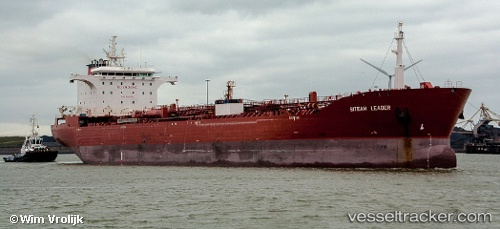
 TORM LEADER
Current Status
Where is the vessel?
TORM LEADER is currently in 38 nm SW of Nindakara, based on AIS data received less than 1h ago.
Latest AIS update:
Current position: 8.60518° N, 75.98959° E (38 nm SW of Nindakara)
Average speed (last 7 days): Loading…
Average speed (last 30 days): Loading…
Vessel profile: TORM LEADER is a Chemical/Oil Products Tanker with dimensions 183m x 183m.
This page combines live AIS, route history, probable destination signals, nearby traffic, and port activity for practical vessel monitoring.
The current position of vessel TORM LEADER is 8.60518 lat / 75.98959 lng. Updated: 2026-05-15 04:10:52 UTCNearest reference points:
- Near Edappally
- Near Cochin
- 41 nm S of Nagercoil
Currently sailing under the flag of Denmark (DIS) ![]()
TORM LEADER built in 2009 year
Deadweight:
46070 tDetails:
Live Vessel TORM LEADER Analytics (details, animations, etc.)
Recent AIS points (UTC):
2026-05-14 23:39:01 UTC · 9.50932, 75.47976 · SOG 13.8 kn · COG 148°2026-05-14 23:39:01 UTC · 9.50932, 75.47976 · SOG 13.8 kn · COG 148°
2026-05-15 01:52:11 UTC · 9.05014, 75.71456 · SOG 13.3 kn · COG 146°
2026-05-15 04:10:52 UTC · 8.60518, 75.98959 · SOG 13.3 kn · COG 146°