 vesseltracker.com
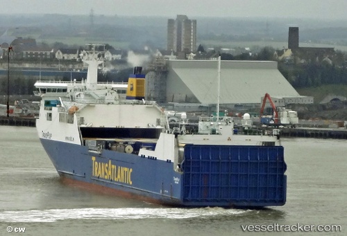
 Thuleland
Current Status
Where is the vessel?
Thuleland is currently in Near Llanwrda, based on AIS data received about 1h ago.
Latest AIS update:
Current position: 52.04541° N, 3.69643° E (Near Llanwrda)
Average speed (last 7 days): Loading…
Average speed (last 30 days): Loading…
Vessel profile: Thuleland is a Ro Ro Cargo Ship with dimensions 191m x 26m.
This page combines live AIS, route history, probable destination signals, nearby traffic, and port activity for practical vessel monitoring.
The current position of vessel Thuleland is 52.04541 lat / 3.69643 lng. Updated: 2026-05-13 19:52:52 UTCNearest reference points:
- 12 nm NE of Hunsdon
- Near Haarlemmermeer
- Near MAASVLAKTE - ROTTERDAM
Currently sailing under the flag of Sweden ![]()
Thuleland built in 2006 year
Deadweight:
13800 tDetails:
Live Vessel Thuleland Analytics (details, animations, etc.)
Recent AIS points (UTC):
2026-05-13 16:31:12 UTC · 51.94636, 4.12763 · SOG 0.1 kn · COG 236°2026-05-13 17:25:20 UTC · 51.94635, 4.12763 · SOG 0.1 kn · COG 22°
2026-05-13 19:50:30 UTC · 52.04485, 3.70862 · SOG 13.6 kn · COG 277°
2026-05-13 19:52:52 UTC · 52.04541, 3.69643 · SOG 13.7 kn · COG 277°