 vesseltracker.com
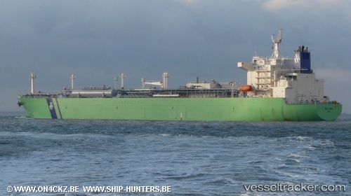
 NY LORD
Current Status
Where is the vessel?
NY LORD is currently in Near LIMAY, based on AIS data received less than 1h ago.
Latest AIS update:
Current position: 14.48883° N, 120.63980° E (Near LIMAY)
Average speed (last 7 days): Loading…
Average speed (last 30 days): Loading…
Vessel profile: NY LORD is a Lpg Tanker with dimensions m x m.
This page combines live AIS, route history, probable destination signals, nearby traffic, and port activity for practical vessel monitoring.
The current position of vessel NY LORD is 14.48883 lat / 120.63980 lng. Updated: 2026-05-15 22:14:08 UTCNearest reference points:
- Near Noveleta
- Near Malabon
- Near MANILA SOUTH HARBOR
Currently sailing under the flag of Liberia ![]()
Details:
Live Vessel NY LORD Analytics (details, animations, etc.)
Recent AIS points (UTC):
2026-05-15 17:56:09 UTC · 14.48900, 120.63962 · SOG 0 kn · COG 26°2026-05-15 18:29:10 UTC · 14.48899, 120.63959 · SOG 0 kn · COG 27°
2026-05-15 19:41:06 UTC · 14.48890, 120.64002 · SOG 0 kn · COG 12°
2026-05-15 22:14:08 UTC · 14.48883, 120.63980 · SOG 0 kn · COG 17°