 vesseltracker.com
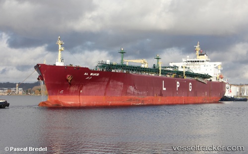
Al Wukir
Current StatusWhere is the vessel?
Al Wukir is currently in 324 nm E of Sundance, based on AIS data received less than 1h ago.
Latest AIS update:
Current position: 25.46962° N, 129.34167° W (324 nm E of Sundance)
Average speed (last 7 days): Loading…
Average speed (last 30 days): Loading…
Vessel profile: Al Wukir is a Lpg Tanker with dimensions 36m x 225m.
This page combines live AIS, route history, probable destination signals, nearby traffic, and port activity for practical vessel monitoring.
The current position of vessel Al Wukir is 25.46962 lat / -129.34167 lng. Updated: 2026-05-16 13:25:48 UTCNearest reference points:
- Open sea, approx. 400 nm off the nearest listed port
- Open sea, approx. 401 nm off the nearest listed port
- Open sea, approx. 404 nm off the nearest listed port
Details:
Live Vessel Al Wukir Analytics (details, animations, etc.)
Recent AIS points (UTC):
2026-05-16 09:48:27 UTC · 25.24812, -128.42686 · SOG 14.1 kn · COG 288°2026-05-16 10:05:39 UTC · 25.26763, -128.49841 · SOG 14.1 kn · COG 288°
2026-05-16 11:49:06 UTC · 25.37341, -128.93192 · SOG 14.3 kn · COG 285°
2026-05-16 13:25:48 UTC · 25.46962, -129.34167 · SOG 14 kn · COG 285°