 vesseltracker.com
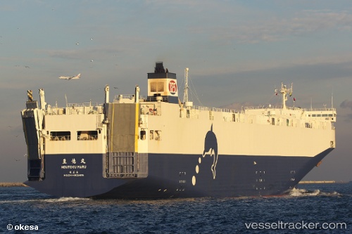
 Houtoku Maru
Current Status
Where is the vessel?
Houtoku Maru is currently in 22 nm SE of ONAHAMA, based on AIS data received less than 1h ago.
Latest AIS update:
Current position: 36.60210° N, 141.08984° E (22 nm SE of ONAHAMA)
Average speed (last 7 days): Loading…
Average speed (last 30 days): Loading…
Vessel profile: Houtoku Maru is a Vehicles Carrier with dimensions 165m x 165m.
This page combines live AIS, route history, probable destination signals, nearby traffic, and port activity for practical vessel monitoring.
The current position of vessel Houtoku Maru is 36.60210 lat / 141.08984 lng. Updated: 2026-04-27 16:07:25 UTCNearest reference points:
- Near Mito
- 37 nm E of ONAHAMA
- 31 nm NE of ONAHAMA
Currently sailing under the flag of Japan ![]()
Houtoku Maru built in 2006 year
Deadweight:
5490 tDetails:
Live Vessel Houtoku Maru Analytics (details, animations, etc.)
Recent AIS points (UTC):
2026-04-27 12:09:01 UTC · 37.75497, 141.19588 · SOG 18.1 kn · COG 179°2026-04-27 14:08:22 UTC · 37.16400, 141.17535 · SOG 16.7 kn · COG 188°
2026-04-27 16:03:37 UTC · 36.61990, 141.09250 · SOG 17 kn · COG 186°
2026-04-27 16:07:25 UTC · 36.60210, 141.08984 · SOG 17 kn · COG 185°