 vesseltracker.com
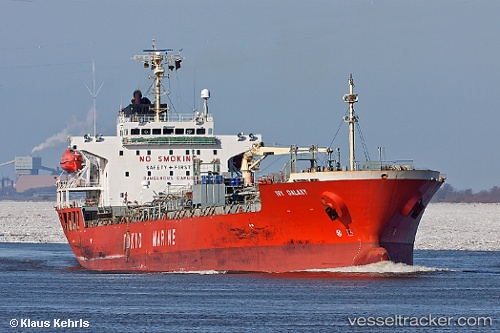
 GOBY
GOBY
Current Status
Where is the vessel?
GOBY is currently in 26 nm NW of Karkinagri Ikarias, based on AIS data received less than 1h ago.
Latest AIS update:
Current position: 37.85532° N, 25.66142° E (26 nm NW of Karkinagri Ikarias)
Average speed (last 7 days): Loading…
Average speed (last 30 days): Loading…
Vessel profile: GOBY is a Oil/Chemical Tanker with dimensions m x m.
This page combines live AIS, route history, probable destination signals, nearby traffic, and port activity for practical vessel monitoring.
The current position of vessel GOBY is 37.85532 lat / 25.66142 lng. Updated: 2026-04-27 11:27:44 UTCNearest reference points:
- 13 nm NW of Karkinagri Ikarias
- Near MYKONOS OLD PORT
- Near Delos
Currently sailing under the flag of Marshall Islands ![]()
Details:
Live Vessel GOBY Analytics (details, animations, etc.)
Recent AIS points (UTC):
2026-04-27 07:45:25 UTC · 37.27563, 26.22640 · SOG 11.7 kn · COG 306°2026-04-27 09:53:55 UTC · 37.55811, 25.80930 · SOG 12 kn · COG 339°
2026-04-27 10:11:05 UTC · 37.61222, 25.78553 · SOG 12 kn · COG 337°
2026-04-27 11:27:44 UTC · 37.85532, 25.66142 · SOG 12.3 kn · COG 337°