 vesseltracker.com
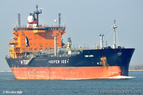
 Torm Laura
Current Status
Where is the vessel?
Torm Laura is currently in Near Acajutla, based on AIS data received about 4h ago.
Latest AIS update:
Current position: 13.55395° N, 89.85900° W (Near Acajutla)
Average speed (last 7 days): Loading…
Average speed (last 30 days): Loading…
Vessel profile: Torm Laura is a Chemical Oil Products Tanker with dimensions 183m x 32m.
This page combines live AIS, route history, probable destination signals, nearby traffic, and port activity for practical vessel monitoring.
The current position of vessel Torm Laura is 13.55395 lat / -89.85900 lng. Updated: 2026-05-14 23:29:25 UTCNearest reference points:
- Near San Jose
- Near El Salvador
- 14 nm NW of Puerto Cortes
Currently sailing under the flag of Denmark ![]()
Torm Laura built in 2008 year
Deadweight:
53160 tDetails:
Live Vessel Torm Laura Analytics (details, animations, etc.)
Recent AIS points (UTC):
2026-05-14 19:41:25 UTC · 13.55414, -89.85974 · SOG 0.1 kn · COG 173°2026-05-14 21:47:25 UTC · 13.55406, -89.85932 · SOG 0.1 kn · COG 182°
2026-05-14 23:08:25 UTC · 13.55395, -89.85895 · SOG 0.1 kn · COG 196°
2026-05-14 23:29:25 UTC · 13.55395, -89.85900 · SOG 0 kn · COG 196°