 vesseltracker.com
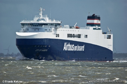
 City Of Hamburg
Current Status
Where is the vessel?
City Of Hamburg is currently in 14 nm S of Hackbridge, based on AIS data received less than 1h ago.
Latest AIS update:
Current position: 51.13676° N, 9.16712° W (14 nm S of Hackbridge)
Average speed (last 7 days): Loading…
Average speed (last 30 days): Loading…
Vessel profile: City Of Hamburg is a Ro Ro Cargo Ship with dimensions 125m x 26m.
This page combines live AIS, route history, probable destination signals, nearby traffic, and port activity for practical vessel monitoring.
The current position of vessel City Of Hamburg is 51.13676 lat / -9.16712 lng. Updated: 2026-05-14 16:32:28 UTCNearest reference points:
- Near Skull
- Near CASTLETOWN BEARHAVEN
- Near Covent Garden
Currently sailing under the flag of France ![]()
City Of Hamburg built in 2008 year
Deadweight:
3546 tDetails:
Live Vessel City Of Hamburg Analytics (details, animations, etc.)
Recent AIS points (UTC):
2026-05-14 13:39:56 UTC · 51.10159, -10.03795 · SOG 12.3 kn · COG 78°2026-05-14 14:04:58 UTC · 51.10718, -9.90077 · SOG 12.6 kn · COG 79°
2026-05-14 15:40:37 UTC · 51.13068, -9.40245 · SOG 10.8 kn · COG 83°
2026-05-14 16:32:28 UTC · 51.13676, -9.16712 · SOG 10.2 kn · COG 84°