 vesseltracker.com
 A KEIGA
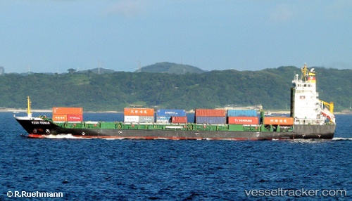
Current Status
Where is the vessel?
A KEIGA is currently in Near Bali, based on AIS data received less than 1h ago.
Latest AIS update:
Current position: 25.16420° N, 121.39046° E (Near Bali)
Average speed (last 7 days): Loading…
Average speed (last 30 days): Loading…
Vessel profile: A KEIGA is a Container Ship with dimensions 132m x 19m.
This page combines live AIS, route history, probable destination signals, nearby traffic, and port activity for practical vessel monitoring.
The current position of vessel A KEIGA is 25.16420 lat / 121.39046 lng. Updated: 2026-05-14 11:59:21 UTCNearest reference points:
- Near Bali
- Near Sha-lun
- 11 nm NE of Bali
Currently sailing under the flag of Hong Kong, China ![]()
A KEIGA built in 2008 year
Deadweight:
8279 tDetails:
Live Vessel A KEIGA Analytics (details, animations, etc.)
Recent AIS points (UTC):
2026-05-14 07:52:50 UTC · 25.16422, 121.39048 · SOG 0 kn · COG 247°2026-05-14 10:28:51 UTC · 25.16418, 121.39045 · SOG 0 kn · COG 247°
2026-05-14 10:58:50 UTC · 25.16416, 121.39043 · SOG 0 kn · COG 247°
2026-05-14 11:59:21 UTC · 25.16420, 121.39046 · SOG 0 kn · COG 246°