 vesseltracker.com
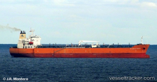
 SEAWAYS MIRAGE
Current Status
Where is the vessel?
SEAWAYS MIRAGE is currently in 34 nm SE of Kenton-on-Sea, based on AIS data received about 1h ago.
Latest AIS update:
Current position: 34.10582° S, 27.07785° E (34 nm SE of Kenton-on-Sea)
Average speed (last 7 days): Loading…
Average speed (last 30 days): Loading…
Vessel profile: SEAWAYS MIRAGE is a Oil/Chemical Tanker with dimensions m x m.
This page combines live AIS, route history, probable destination signals, nearby traffic, and port activity for practical vessel monitoring.
The current position of vessel SEAWAYS MIRAGE is -34.10582 lat / 27.07785 lng. Updated: 2026-05-15 01:02:01 UTCNearest reference points:
- Near Deal Party
- 21 nm S of Mount Pleasant
Currently sailing under the flag of Marshall Islands ![]()
Details:
Live Vessel SEAWAYS MIRAGE Analytics (details, animations, etc.)
Recent AIS points (UTC):
2026-05-14 21:37:54 UTC · -33.68320, 27.84403 · SOG 13.8 kn · COG 236°2026-05-14 22:40:15 UTC · -33.83627, 27.63530 · SOG 13.7 kn · COG 236°
2026-05-14 23:58:10 UTC · -33.99597, 27.33308 · SOG 13.1 kn · COG 240°
2026-05-15 01:02:01 UTC · -34.10582, 27.07785 · SOG 12.8 kn · COG 255°