 vesseltracker.com
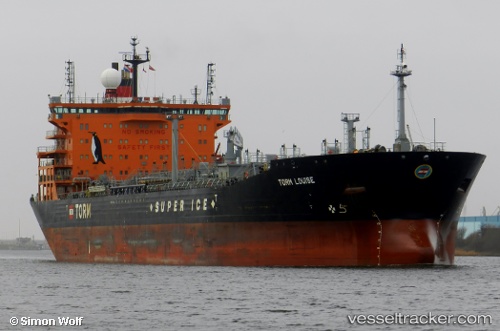
 Torm Louise
Current Status
Where is the vessel?
Torm Louise is currently in Near San Lorenzo, based on AIS data received less than 1h ago.
Latest AIS update:
Current position: 32.73160° S, 60.72712° W (Near San Lorenzo)
Average speed (last 7 days): Loading…
Average speed (last 30 days): Loading…
Vessel profile: Torm Louise is a Chemical Oil Products Tanker with dimensions 183m x 32m.
This page combines live AIS, route history, probable destination signals, nearby traffic, and port activity for practical vessel monitoring.
The current position of vessel Torm Louise is -32.73160 lat / -60.72712 lng. Updated: 2026-05-14 09:35:21 UTCNearest reference points:
- Near Quebracho/San Lorenzo
- Near Puerto Alumbrera
- 10 nm NW of San Pedro
Currently sailing under the flag of Denmark ![]()
Torm Louise built in 2009 year
Deadweight:
53160 tDetails:
Live Vessel Torm Louise Analytics (details, animations, etc.)
Recent AIS points (UTC):
2026-05-14 06:11:27 UTC · -32.73163, -60.72712 · SOG 0 kn · COG 351°2026-05-14 07:29:26 UTC · -32.73161, -60.72712 · SOG 0 kn · COG 352°
2026-05-14 07:41:26 UTC · -32.73161, -60.72712 · SOG 0 kn · COG 351°
2026-05-14 09:35:21 UTC · -32.73160, -60.72712 · SOG 0 kn · COG 352°