 vesseltracker.com
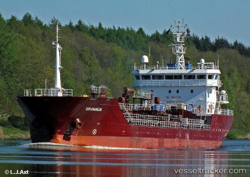
 ORAMALIA
Current Status
Where is the vessel?
ORAMALIA is currently in 11 nm W of Le Portel, based on AIS data received less than 1h ago.
Latest AIS update:
Current position: 50.67667° N, 1.29297° E (11 nm W of Le Portel)
Average speed (last 7 days): Loading…
Average speed (last 30 days): Loading…
Vessel profile: ORAMALIA is a Chemical/Oil Products Tanker with dimensions 103m x 16m.
This page combines live AIS, route history, probable destination signals, nearby traffic, and port activity for practical vessel monitoring.
The current position of vessel ORAMALIA is 50.67667 lat / 1.29297 lng. Updated: 2026-05-15 10:16:27 UTCNearest reference points:
- Near Le Portel
- Near Folkestone
- Near Dungeness
Currently sailing under the flag of Portugal (MAR) ![]()
ORAMALIA built in 2007 year
Deadweight:
6863 tDetails:
Live Vessel ORAMALIA Analytics (details, animations, etc.)
Recent AIS points (UTC):
2026-05-15 07:09:58 UTC · 50.42106, 0.45727 · SOG 12.4 kn · COG 75°2026-05-15 07:38:08 UTC · 50.44650, 0.60219 · SOG 12.1 kn · COG 76°
2026-05-15 10:01:37 UTC · 50.64306, 1.23805 · SOG 11.6 kn · COG 51°
2026-05-15 10:16:27 UTC · 50.67667, 1.29297 · SOG 11.8 kn · COG 51°