 vesseltracker.com
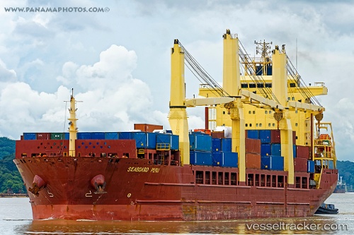
 Seaboard Peru
Current Status
Where is the vessel?
Seaboard Peru is currently in 76 nm SE of Shidao Pt, based on AIS data received less than 1h ago.
Latest AIS update:
Current position: 35.76167° N, 123.20333° E (76 nm SE of Shidao Pt)
Average speed (last 7 days): Loading…
Average speed (last 30 days): Loading…
Vessel profile: Seaboard Peru is a Multi Purpose Carrier with dimensions 160m x 160m.
This page combines live AIS, route history, probable destination signals, nearby traffic, and port activity for practical vessel monitoring.
The current position of vessel Seaboard Peru is 35.76167 lat / 123.20333 lng. Updated: 2026-05-16 07:11:33 UTCNearest reference points:
- 83 nm SE of Shidao Pt
- 67 nm SE of Shidao Pt
- 67 nm S of Shidao Pt
Currently sailing under the flag of Cyprus ![]()
Seaboard Peru built in 2010 year
Deadweight:
25774 tDetails:
Live Vessel Seaboard Peru Analytics (details, animations, etc.)
Recent AIS points (UTC):
2026-05-16 04:21:25 UTC · 36.40008, 123.22852 · SOG 13.9 kn · COG 181°2026-05-16 05:00:36 UTC · 36.25007, 123.22073 · SOG 13.6 kn · COG 190°
2026-05-16 05:41:15 UTC · 36.09799, 123.20074 · SOG 13.5 kn · COG 178°
2026-05-16 07:11:33 UTC · 35.76167, 123.20333 · SOG 13 kn · COG -1°