 vesseltracker.com
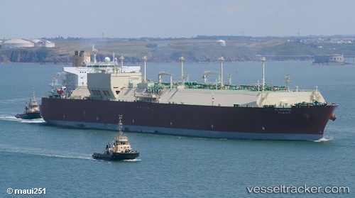
Al Mayeda
Current StatusWhere is the vessel?
Al Mayeda is currently in 18 nm W of Colombo, based on AIS data received less than 1h ago.
Latest AIS update:
Current position: 6.92370° N, 79.54385° E (18 nm W of Colombo)
Average speed (last 7 days): Loading…
Average speed (last 30 days): Loading…
Vessel profile: Al Mayeda is a Lng Tanker with dimensions 52m x 345m.
This page combines live AIS, route history, probable destination signals, nearby traffic, and port activity for practical vessel monitoring.
The current position of vessel Al Mayeda is 6.92370 lat / 79.54385 lng. Updated: 2026-05-13 21:29:48 UTCNearest reference points:
- 67 nm SW of Moratuwa
- 19 nm SW of Bataduwa
- 82 nm W of Moratuwa
Details:
Live Vessel Al Mayeda Analytics (details, animations, etc.)
Recent AIS points (UTC):
2026-05-13 18:14:18 UTC · 6.85618, 79.50633 · SOG 1.8 kn · COG 145°2026-05-13 19:11:17 UTC · 6.86455, 79.53902 · SOG 2.1 kn · COG 321°
2026-05-13 19:59:17 UTC · 6.88245, 79.51928 · SOG 1.8 kn · COG 307°
2026-05-13 21:29:48 UTC · 6.92370, 79.54385 · SOG 2.5 kn · COG 270°