 vesseltracker.com
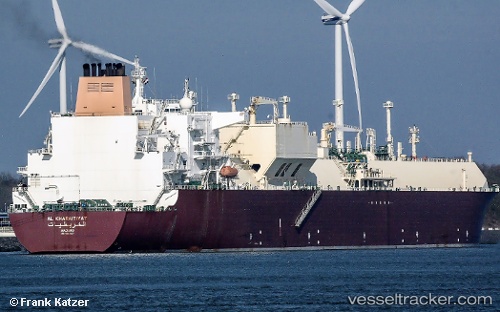
 Al Kharaitiyat
Current Status
Where is the vessel?
Al Kharaitiyat is currently in Near PORT QASIM, based on AIS data received about 3h ago.
Latest AIS update:
Current position: 24.77091° N, 67.31217° E (Near PORT QASIM)
Average speed (last 7 days): Loading…
Average speed (last 30 days): Loading…
Vessel profile: Al Kharaitiyat is a Lng Tanker with dimensions 315m x 50m.
This page combines live AIS, route history, probable destination signals, nearby traffic, and port activity for practical vessel monitoring.
The current position of vessel Al Kharaitiyat is 24.77091 lat / 67.31217 lng. Updated: 2026-05-14 13:04:10 UTCNearest reference points:
- Near PORT QASIM
- Near Kiamari
- 16 nm S of Kiamari
Currently sailing under the flag of Marshall Is ![]()
Al Kharaitiyat built in 2009 year
Deadweight:
107153 tDetails:
Live Vessel Al Kharaitiyat Analytics (details, animations, etc.)
Recent AIS points (UTC):
2026-05-14 12:16:09 UTC · 24.77091, 67.31215 · SOG 0 kn · COG 307°2026-05-14 13:04:10 UTC · 24.77091, 67.31217 · SOG 0 kn · COG 307°
2026-05-14 13:04:10 UTC · 24.77091, 67.31217 · SOG 0 kn · COG 307°
2026-05-14 13:04:10 UTC · 24.77091, 67.31217 · SOG 0 kn · COG 307°