 vesseltracker.com
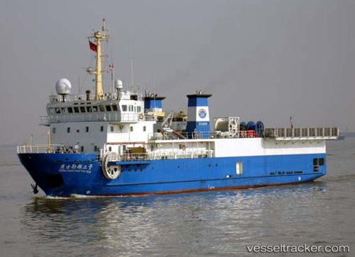
 DONG FANG KAN TAN NO. 2
Current Status
Where is the vessel?
DONG FANG KAN TAN NO. 2 is currently in Near Rak Maritime City, based on AIS data received less than 1h ago.
Latest AIS update:
Current position: 25.94746° N, 56.05999° E (Near Rak Maritime City)
Average speed (last 7 days): Loading…
Average speed (last 30 days): Loading…
Vessel profile: DONG FANG KAN TAN NO. 2 is a Research Vessel with dimensions 18m x 65m.
This page combines live AIS, route history, probable destination signals, nearby traffic, and port activity for practical vessel monitoring.
The current position of vessel DONG FANG KAN TAN NO. 2 is 25.94746 lat / 56.05999 lng. Updated: 2026-05-16 03:01:45 UTCNearest reference points:
- Near Rak Maritime City
- Near Stevin Rock
- Near Ras Al Khaimah
Currently sailing under the flag of Panama ![]()
DONG FANG KAN TAN NO. 2 built in 2006 year
Deadweight:
650 tDetails:
Live Vessel DONG FANG KAN TAN NO. 2 Analytics (details, animations, etc.)
Recent AIS points (UTC):
2026-05-16 00:07:45 UTC · 25.94742, 56.06002 · SOG 0 kn · COG 354°2026-05-16 01:13:45 UTC · 25.94741, 56.06001 · SOG 0 kn · COG 354°
2026-05-16 02:34:45 UTC · 25.94743, 56.06000 · SOG 0 kn · COG 354°
2026-05-16 03:01:45 UTC · 25.94746, 56.05999 · SOG 0 kn · COG 354°