 vesseltracker.com
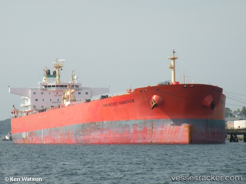
 Paramount Hanover
Current Status
Where is the vessel?
Paramount Hanover is currently in Near Papar, based on AIS data received about 1h ago.
Latest AIS update:
Current position: 5.74280° N, 115.77259° E (Near Papar)
Average speed (last 7 days): Loading…
Average speed (last 30 days): Loading…
Vessel profile: Paramount Hanover is a Crude Oil Tanker with dimensions 250m x 44m.
This page combines live AIS, route history, probable destination signals, nearby traffic, and port activity for practical vessel monitoring.
The current position of vessel Paramount Hanover is 5.74280 lat / 115.77259 lng. Updated: 2026-04-26 03:09:28 UTCNearest reference points:
- Near Kota Kinabalu
- 44 nm SW of Tembungo
- Near Kikeh
Currently sailing under the flag of United Kingdom ![]()
Paramount Hanover built in 2010 year
Deadweight:
114014 tDetails:
Live Vessel Paramount Hanover Analytics (details, animations, etc.)
Recent AIS points (UTC):
2026-04-25 22:51:28 UTC · 5.74194, 115.77137 · SOG 0 kn · COG 347°2026-04-26 01:27:28 UTC · 5.74224, 115.77184 · SOG 0 kn · COG 331°
2026-04-26 01:27:28 UTC · 5.74224, 115.77184 · SOG 0 kn · COG 331°
2026-04-26 03:09:28 UTC · 5.74280, 115.77259 · SOG 0 kn · COG 302°