 vesseltracker.com
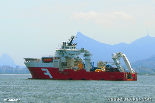
 Far Samson
Current Status
Where is the vessel?
Far Samson is currently in 23 nm NE of Enmore, based on AIS data received less than 1h ago.
Latest AIS update:
Current position: 7.11016° N, 57.81349° W (23 nm NE of Enmore)
Average speed (last 7 days): Loading…
Average speed (last 30 days): Loading…
Vessel profile: Far Samson is a Offshore Support Vessel with dimensions 121m x 26m.
This page combines live AIS, route history, probable destination signals, nearby traffic, and port activity for practical vessel monitoring.
The current position of vessel Far Samson is 7.11016 lat / -57.81349 lng. Updated: 2026-05-14 20:16:48 UTCNearest reference points:
- 57 nm NE of Adventure
- 38 nm NW of Jarikaba
Currently sailing under the flag of Norway ![]()
Far Samson built in 2009 year
Deadweight:
9000 tDetails:
Live Vessel Far Samson Analytics (details, animations, etc.)
Recent AIS points (UTC):
2026-05-14 15:21:49 UTC · 7.11015, -57.81350 · SOG 0 kn · COG 69°2026-05-14 17:22:08 UTC · 7.11015, -57.81349 · SOG 0.1 kn · COG 69°
2026-05-14 19:11:17 UTC · 7.11016, -57.81348 · SOG 0.2 kn · COG 70°
2026-05-14 20:16:48 UTC · 7.11016, -57.81349 · SOG 0 kn · COG 70°