 vesseltracker.com
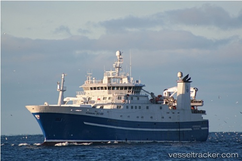
 Nordborg
Current Status
Where is the vessel?
Nordborg is currently in Near Torshavn, based on AIS data received less than 1h ago.
Latest AIS update:
Current position: 62.00583° N, 6.77150° W (Near Torshavn)
Average speed (last 7 days): Loading…
Average speed (last 30 days): Loading…
Vessel profile: Nordborg is a Fish Carrier with dimensions m x m.
This page combines live AIS, route history, probable destination signals, nearby traffic, and port activity for practical vessel monitoring.
The current position of vessel Nordborg is 62.00583 lat / -6.77150 lng. Updated: 2026-05-01 22:33:33 UTCNearest reference points:
- Near FUGLAFJORDUR
- Near VESTMANNA
- 20 nm S of Vágur
Currently sailing under the flag of Faroe Is ![]()
Nordborg built in 2009 year
Deadweight:
4000 tDetails:
Live Vessel Nordborg Analytics (details, animations, etc.)
Recent AIS points (UTC):
2026-05-01 19:12:42 UTC · 62.00583, -6.77150 · SOG 0 kn · COG 147°2026-05-01 19:56:32 UTC · 62.00583, -6.77150 · SOG 0 kn · COG 147°
2026-05-01 22:10:53 UTC · 62.00583, -6.77150 · SOG 0 kn · COG 146°
2026-05-01 22:33:33 UTC · 62.00583, -6.77150 · SOG 0 kn · COG 148°