 vesseltracker.com
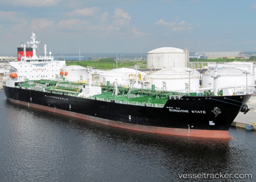
 Sunshine State
Current Status
Where is the vessel?
Sunshine State is currently in Open sea (no nearby ports in database), based on AIS data received less than 1h ago.
Latest AIS update:
Current position: 31.96393° N, 176.55098° E (Open sea (no nearby ports in database))
Average speed (last 7 days): Loading…
Average speed (last 30 days): Loading…
Vessel profile: Sunshine State is a Chemical Oil Products Tanker with dimensions 183m x 32m.
This page combines live AIS, route history, probable destination signals, nearby traffic, and port activity for practical vessel monitoring.
The current position of vessel Sunshine State is 31.96393 lat / 176.55098 lng. Updated: 2026-05-14 22:09:07 UTCNearest reference points:
- Open sea (no nearby ports in database)
Currently sailing under the flag of USA ![]()
Sunshine State built in 2009 year
Deadweight:
48633 tDetails:
Live Vessel Sunshine State Analytics (details, animations, etc.)
Recent AIS points (UTC):
2026-05-14 19:02:03 UTC · 31.82598, 175.73965 · SOG 13.8 kn · COG 81°2026-05-14 20:07:16 UTC · 31.87372, 176.02940 · SOG 13.8 kn · COG 79°
2026-05-14 22:08:25 UTC · 31.96345, 176.54810 · SOG 13.2 kn · COG 78°
2026-05-14 22:09:07 UTC · 31.96393, 176.55098 · SOG 13.3 kn · COG 78°