 vesseltracker.com
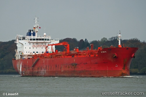
 STAR C
Current Status
Where is the vessel?
STAR C is currently in 15 nm NW of Middelkerke, based on AIS data received less than 1h ago.
Latest AIS update:
Current position: 51.39999° N, 2.60143° E (15 nm NW of Middelkerke)
Average speed (last 7 days): Loading…
Average speed (last 30 days): Loading…
Vessel profile: STAR C is a Chemical Oil Products Tanker with dimensions 184m x 27m.
This page combines live AIS, route history, probable destination signals, nearby traffic, and port activity for practical vessel monitoring.
The current position of vessel STAR C is 51.39999 lat / 2.60143 lng. Updated: 2026-05-16 10:03:06 UTCNearest reference points:
- 13 nm NW of Middelkerke
- Near Lombardsijde
- Near Oostende
Currently sailing under the flag of Liberia ![]()
STAR C built in 2009 year
Deadweight:
37836 tDetails:
Live Vessel STAR C Analytics (details, animations, etc.)
Recent AIS points (UTC):
2026-05-16 07:30:11 UTC · 51.39887, 2.59623 · SOG 0.3 kn · COG 61°2026-05-16 07:42:13 UTC · 51.39847, 2.59692 · SOG 0.2 kn · COG 357°
2026-05-16 09:33:45 UTC · 51.39833, 2.59667 · SOG 0 kn · COG -1°
2026-05-16 10:03:06 UTC · 51.39999, 2.60143 · SOG 0.3 kn · COG 281°