 vesseltracker.com
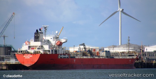
 JBU SAPPHIRE
Current Status
Where is the vessel?
JBU SAPPHIRE is currently in Near New Priok Port, based on AIS data received about 1h ago.
Latest AIS update:
Current position: 6.09897° S, 106.90595° E (Near New Priok Port)
Average speed (last 7 days): Loading…
Average speed (last 30 days): Loading…
Vessel profile: JBU SAPPHIRE is a Chemical/Oil Products Tanker with dimensions 24m x 141m.
This page combines live AIS, route history, probable destination signals, nearby traffic, and port activity for practical vessel monitoring.
The current position of vessel JBU SAPPHIRE is -6.09897 lat / 106.90595 lng. Updated: 2026-05-02 13:47:05 UTCNearest reference points:
- Near Jakarta
- Near New Priok Port
- Near Ancol
Currently sailing under the flag of Korea (Republic of) ![]()
JBU SAPPHIRE built in 2009 year
Deadweight:
19860 tDetails:
Live Vessel JBU SAPPHIRE Analytics (details, animations, etc.)
Recent AIS points (UTC):
2026-05-02 10:20:02 UTC · -6.09890, 106.90593 · SOG 0 kn · COG 3°2026-05-02 12:17:05 UTC · -6.09890, 106.90587 · SOG 0 kn · COG 3°
2026-05-02 13:23:05 UTC · -6.09893, 106.90597 · SOG 0 kn · COG 3°
2026-05-02 13:47:05 UTC · -6.09897, 106.90595 · SOG 0 kn · COG 3°