 vesseltracker.com
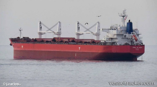
 VOSCO DEFENDER
Current Status
Where is the vessel?
VOSCO DEFENDER is currently in Near Tips Container Terminal, based on AIS data received about 1h ago.
Latest AIS update:
Current position: 13.05273° N, 100.83605° E (Near Tips Container Terminal)
Average speed (last 7 days): Loading…
Average speed (last 30 days): Loading…
Vessel profile: VOSCO DEFENDER is a Bulk Carrier with dimensions m x m.
This page combines live AIS, route history, probable destination signals, nearby traffic, and port activity for practical vessel monitoring.
The current position of vessel VOSCO DEFENDER is 13.05273 lat / 100.83605 lng. Updated: 2026-05-14 01:36:37 UTCNearest reference points:
- Near Tips Container Terminal
- Near Sriracha
- Near SIRACHA
Currently sailing under the flag of Panama ![]()
Details:
Live Vessel VOSCO DEFENDER Analytics (details, animations, etc.)
Recent AIS points (UTC):
2026-05-13 22:15:36 UTC · 13.05190, 100.83745 · SOG 0.1 kn · COG 89°2026-05-13 23:45:36 UTC · 13.05320, 100.83823 · SOG 0.2 kn · COG 61°
2026-05-14 01:03:37 UTC · 13.05195, 100.84003 · SOG 0.2 kn · COG 74°
2026-05-14 01:36:37 UTC · 13.05273, 100.83605 · SOG 0.1 kn · COG 99°