 vesseltracker.com
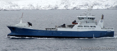
 Ro Master
Current Status
Where is the vessel?
Ro Master is currently in Near Skjervøy, based on AIS data received less than 1h ago.
Latest AIS update:
Current position: 70.04654° N, 21.28414° E (Near Skjervøy)
Average speed (last 7 days): Loading…
Average speed (last 30 days): Loading…
Vessel profile: Ro Master is a Fish Carrier with dimensions 72m x 15m.
This page combines live AIS, route history, probable destination signals, nearby traffic, and port activity for practical vessel monitoring.
The current position of vessel Ro Master is 70.04654 lat / 21.28414 lng. Updated: 2026-05-14 00:15:15 UTCNearest reference points:
- Near Skjervøy
- Near Sørkjosen
- Near SORVAR
Currently sailing under the flag of Norway ![]()
Ro Master built in 2007 year
Deadweight:
3090 tDetails:
Live Vessel Ro Master Analytics (details, animations, etc.)
Recent AIS points (UTC):
2026-05-13 20:17:57 UTC · 70.06878, 21.05619 · SOG 9.9 kn · COG 86°2026-05-13 21:35:05 UTC · 70.04474, 21.28507 · SOG 0 kn · COG 172°
2026-05-13 22:42:25 UTC · 70.04569, 21.28464 · SOG 0 kn · COG 171°
2026-05-14 00:15:15 UTC · 70.04654, 21.28414 · SOG 0.1 kn · COG 172°