 vesseltracker.com
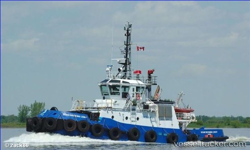
Ocean Raymond Lemay
Current StatusWhere is the vessel?
Ocean Raymond Lemay is currently in Near SEPT-ILES, based on AIS data received about 2h ago.
Latest AIS update:
Current position: 50.19922° N, 66.38191° W (Near SEPT-ILES)
Average speed (last 7 days): Loading…
Average speed (last 30 days): Loading…
Vessel profile: Ocean Raymond Lemay is a Tug with dimensions 10m x 31m.
This page combines live AIS, route history, probable destination signals, nearby traffic, and port activity for practical vessel monitoring.
The current position of vessel Ocean Raymond Lemay is 50.19922 lat / -66.38191 lng. Updated: 2026-05-14 22:04:49 UTCNearest reference points:
- 22 nm N of Sainte-Anne-des-Monts
- 15 nm NW of Saint-Anaclet
Details:
Live Vessel Ocean Raymond Lemay Analytics (details, animations, etc.)
Recent AIS points (UTC):
2026-05-14 19:20:59 UTC · 50.19921, -66.38192 · SOG 0 kn · COG 52°2026-05-14 20:22:38 UTC · 50.19924, -66.38191 · SOG 0 kn · COG 52°
2026-05-14 21:23:59 UTC · 50.19923, -66.38191 · SOG 0 kn · COG 52°
2026-05-14 22:04:49 UTC · 50.19922, -66.38191 · SOG 0 kn · COG 52°