 vesseltracker.com
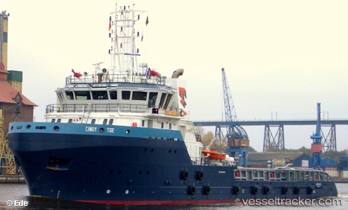
 Cindy Tide
Current Status
Where is the vessel?
Cindy Tide is currently in 27 nm N of Michoacán, based on AIS data received about 2h ago.
Latest AIS update:
Current position: 18.35958° N, 93.87921° W (27 nm N of Michoacán)
Average speed (last 7 days): Loading…
Average speed (last 30 days): Loading…
Vessel profile: Cindy Tide is a Offshore Tug Supply Ship with dimensions 70m x 16m.
This page combines live AIS, route history, probable destination signals, nearby traffic, and port activity for practical vessel monitoring.
The current position of vessel Cindy Tide is 18.35958 lat / -93.87921 lng. Updated: 2026-05-14 03:58:00 UTCNearest reference points:
- Near Coatzacoalcos
- 35 nm S of Yùum K'Ak'Náab
- 18 nm S of Yùum K'Ak'Náab
Currently sailing under the flag of Mexico ![]()
Cindy Tide built in 2008 year
Deadweight:
2020 tDetails:
Live Vessel Cindy Tide Analytics (details, animations, etc.)
Recent AIS points (UTC):
2026-05-14 01:21:44 UTC · 18.38333, -93.89833 · SOG 2 kn · COG -1°2026-05-14 02:03:45 UTC · 18.36500, -93.87667 · SOG 2 kn · COG -1°
2026-05-14 03:54:42 UTC · 18.35667, -93.87500 · SOG 3 kn · COG -1°
2026-05-14 03:58:00 UTC · 18.35958, -93.87921 · SOG 3.3 kn · COG 307°