 vesseltracker.com
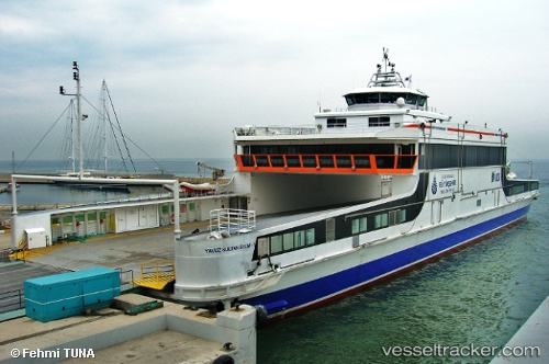
 Yavuz Sultan Selim 1
Current Status
Where is the vessel?
Yavuz Sultan Selim 1 is currently in Near Gebze, based on AIS data received less than 1h ago.
Latest AIS update:
Current position: 40.66067° N, 29.27980° E (Near Gebze)
Average speed (last 7 days): Loading…
Average speed (last 30 days): Loading…
Vessel profile: Yavuz Sultan Selim 1 is a Passenger Ro Ro Cargo Ship with dimensions 85m x 21m.
This page combines live AIS, route history, probable destination signals, nearby traffic, and port activity for practical vessel monitoring.
The current position of vessel Yavuz Sultan Selim 1 is 40.66067 lat / 29.27980 lng. Updated: 2026-04-25 19:26:25 UTCNearest reference points:
- Near TUZLA
- Near Tuzla Free Zone
- Near YALOVA
Currently sailing under the flag of Turkey ![]()
Yavuz Sultan Selim 1 built in 2008 year
Deadweight:
280 tDetails:
Live Vessel Yavuz Sultan Selim 1 Analytics (details, animations, etc.)
Recent AIS points (UTC):
2026-04-25 16:03:49 UTC · 40.93274, 28.99944 · SOG 16 kn · COG -1°2026-04-25 16:41:09 UTC · 41.00147, 28.95847 · SOG 0 kn · COG 197°
2026-04-25 18:08:27 UTC · 40.70132, 29.23072 · SOG 17.4 kn · COG 133°
2026-04-25 19:26:25 UTC · 40.66067, 29.27980 · SOG 0 kn · COG 4°